Copyright © MMXVII SCOPAC Sediment Transport Study. All Rights Reserved

HOME

About the Study

SCOPAC Committee

Chairperson Councillor Mrs M Penfold MBE, West Dorset District Council.

Vice-Chair Councillor Jackie Branson, Havant Borough Council.

Technical assistance provided to Councillors by Mr Lyall Cairns (Southern Coastal Group Chair) and Dr Samantha Cope (SCOPAC Research Chair).

Introduction & Acknowledgements

Methods

Map Design, Symbols & Reliability

User Guide

Bibliographic Database

The STS 2012 update

The 2012 update of the SCOPAC Sediment Transport Study (STS) was funded by the Environment Agency under FDGiA, grant number LDW 41230, with additional contributions from SCOPAC.  

It is referenced as: New Forest District Council (2017). 2012 Update of Carter, D., Bray, M., & Hooke, J., 2004 SCOPAC Sediment Transport Study, www.scopac.org.uk/sts.

Sediment Transport Study 2012

HOMEBIBLIOGRAPHIC DATABASE

South West and South East Isle of Wight

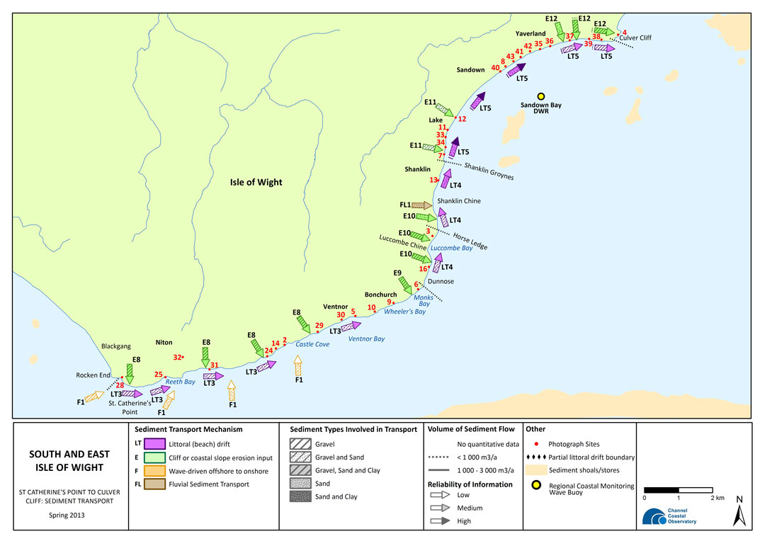
The Needles to St Catherine’s Point to Culver Cliff

E12E12E11FL1E10E10E10E9E8E8E8F1F1F1F1LT3LT3LT3LT3LT3LT4LT4LT4LT5LT5LT5LT5LT5Photo 32Photo 25Photo 28Photo 31Photo 24Photo 14Photo 2Photo 29Photo 30Photo 5Photo 10Photo 9Photo 16Photo 3Photo 13Photo 7Photo 34Photo 33Photo 11Photo 12Photo 40Photo 8Photo 43Photo 41Photo 42Photo 35Photo 36Photo 37Photo 39Photo 4Regional Coastal Monitoring Wave BuoyE12E11Photo 6

24b

Sediment Transport Map

Map 24b below illustrates sediment type, direction, volume, transport mechanism and reliability of information.

The arrows on the map, when clicked, will take you through to supporting information. The supporting information is based on a review of literature from the SCOPAC Bibliographic Database and Regional Coastal Monitoring Programme data analysis up to December 2012.

The available photographs are represented by red, numbered dots which, when clicked, will take you through to the appropriate image, with detailed description, in the gallery.

Wave buoys are represented by a yellow & black circle and link through to a directional wave rose (DWR).

E8 Photo 38 MAP 24a (SW) MAP 24b (SE) LITERATURE REVIEW PHOTOS Download the map as a pdf

​01

Start Point to Berry Head

​02

Berry Head to Hope's Nose (Tor Bay)

​03

Hope's Nose, Torquay to Holcombe

​04

Holcombe to Straight Point (including Exe Estuary)

​05

Straight Point to Otterton Ledge

​06

Otterton Ledge to Beer Head  

​07

Beer Head to Lyme Regis

​08

Lyme Regis to West Bay

​09

West Bay to Portland Bill  

10

Isle of Portland and Weymouth Bay  

11

Redcliff Point to Durlston Head (Purbeck)  

12

Durlston Head to Handfast Point

13

Handfast Point to South Haven Point (Studland Bay)  

14

Poole Harbour

15

Poole Harbour Entrance to Hengistbury Head (Poole Bay)

16

Hengistbury Head to Hurst Spit (Christchurch Bay)

Quaternary History of the Solent

​17

Hurst Spit to Calshot Spit (Western Solent Mainland)  

18

Southampton Water  

19

River Hamble to Portsmouth Harbour Entrance  

20

Portsmouth, Langstone and Chichester Harbours  

21

Portsmouth Harbour Entrance to Chichester Harbour Entrance

22

North West Isle of Wight

23

North East Isle of Wight

24a

South West Isle of Wight  

24b

South East Isle of Wight  

25

East Head to Pagham, West Sussex

26a

Pagham to Littlehampton

26b

Littlehampton to Shoreham-by-Sea  

27a

Shoreham-By-Sea to Newhaven  

27b

Newhaven to Beachy Head  

Introduction & Acknowledgements

Methods

Map Design, Symbols & Reliability

User Guide